


Sebuah catatan di atas kertas usang

Dua lembar kertas usang kembali ku temukan di antara tumpukan buku yang -hampir- tak pernah kubaca, kertas yang berisi catatan perjalanan pendakian gunung Semeru tahun 2005 aku temukan setelah 4 tahun ini aku cari. Bahagia rasanya kembali menemukan catatan itu. Ku baca dan ku baca berulang-ulang, merasakan kembali perjalanan yang penuh suka duka 4 tahun yang lalu.
Dari catatan perjalanan tersebut, aku menuliskannya dalam salah satu blogku yang lain. Memang tidak sesuai dengan apa yang ada dalam kertas usang tersebut, namun tulisan ini lebih kepada informasi pendakian Semeru. Semoga bermanfaat bagi kita semua.
Mount Semeru is the highest volcano in Java. With his "Puncak Mahameru" peak at an altitude of 3.676 meters above sea level (MASL), the Mount is included in the Bromo Tengger Semeru National Park. This mountain is located in the city of Malang and Lumajang.
Semeru is a favorite mountaineering area for Indonesian mountaineers, because it has a great view. Crater "Jonggring Saloko" which is located on top of the "Puncak Mahameru" always blowing a smoke every 15-30 minutes, the smoke is a toxic gas that is very dangerous, the mountaineers are advised not to approach crater, and leave the summit before noon, because the wind blow towards the peak in the afternoon.
Tulisanku ini juga dimuat di : http://indonesianwild.com/semeru-highest-place-in-java/
Dari catatan perjalanan tersebut, aku menuliskannya dalam salah satu blogku yang lain. Memang tidak sesuai dengan apa yang ada dalam kertas usang tersebut, namun tulisan ini lebih kepada informasi pendakian Semeru. Semoga bermanfaat bagi kita semua.
Mount Semeru is the highest volcano in Java. With his "Puncak Mahameru" peak at an altitude of 3.676 meters above sea level (MASL), the Mount is included in the Bromo Tengger Semeru National Park. This mountain is located in the city of Malang and Lumajang.
Semeru is a favorite mountaineering area for Indonesian mountaineers, because it has a great view. Crater "Jonggring Saloko" which is located on top of the "Puncak Mahameru" always blowing a smoke every 15-30 minutes, the smoke is a toxic gas that is very dangerous, the mountaineers are advised not to approach crater, and leave the summit before noon, because the wind blow towards the peak in the afternoon.
- Where's the interesting place?
- Tumpang - Ranu Pani (Ranu = Lake) : off road trip with the view of under the cloud desert, Bromo mount, and Tengger mount.

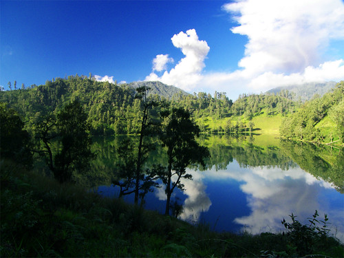
- Ranu Kumbolo : a 14 hectares lake located at an altitude of 2400 MASL, is the best place for camping with a very
- Tanjakan Cinta (Tanjakan = climb, Cinta = love): A climb that is at the end of the Ranu Kumbolo have a myth about the love, that is if someone can climb through without a stop and turn, then his love wishes will be happen. The scenery is good
- Oro-oro Ombo (Oro-oro = Savanna, Ombo = wide): A Savanna is a quite wide and it is surrounded by hills. It has a very interesting scene.
- Kalimati (Kali = river, Mati = dead): A terrain at 2.700 MASL, is located in the pine forest with spectacular view of Puncak Mahameru, this place became one of the favorite areas of photography.
- Puncak Mahameru : The highest place on the Java island, form of paving sand. Overlooking the crater "Jonggring Saloko" that blowing every 15-30 minutes, it was the most beautiful place in Semeru. It was a beautiful scenery.

- When to go?
- Climbing should be done in the dry season( June, July, August, and September). Should not climb in the wet season because of frequent storms and landslides, rainy season occurs in November-April.
- How to get there?
- Come to Malang by bus, train, or plane
- Malang – Tumpang : 30 minutes, use public transport to Tumpang for about Rp. 10,000 / person. Other alternative is to charter a car transportation.
- Tumpang - Ranu Pani : 2 hours, use the Jeep for about Rp. 30.000 / person. Other alternative is to use the vegetable truck (a little amount of people) with a cheaper price (Mr. Machis +62341787490). Bromo Tengger Semeru National Park fee is about Rp. 5,000/person
- Trekking Route:
- Ranu Pani - Base camp (2.200 MASL). Ranu Pani is the Semeru mountain climbing base camp. You can spend the night in the base camp and explore porter. It was sloping climbing path.
- Watu Rejeng. Watu Rejeng (5 KM from Ranu Pani) is a very beautiful steep stone. Scenic pines forest covered a valleys and hills are very beautiful. You also see the explotion of smoke from the top Semeru. It was sloping climbing path
- Ranu Kumbolo (2.400 MASL). Ranu Kumbolo (5 KM from Watu Rejeng, about 5-6 hours from Ranu Pani) is the most strategic place for camping. In addition to water sources and have wood that much, Ranu Kumbolo scene is also very good. It was sloping climbing path.
- Oro-oro Ombo. It’s a wide savanna, It was sloping climbing path, but before entering the Oro-oro Ombo, you have to climb through Tanjakan Cinta that drain enough the energy for about 30 minutes.
- Cemoro Kandang (Cemoro = Pine, Kandang = shed). Cemoro Kandang (about 1 hour from Ranu Kumbolo) is a pine forest on the edge of Oro-oro Ombo. Road began a little steep and quite tiring, Cemoro Kandang ended in Jambangan, a few Edelweiss trees with the Savanna, and Puncak Mahameru in the peak.
- Kalimati (2.700 MASL). Kalimati (5 KM, and about 4 hours from Ranu Kumbolo) is a savanna and a quite strategic for camping. There is also a water source Sumber Mani outside climbing routes (about 30 minutes from Kalimati). It was sloping climbing path
- Arcopodo (2.900 MASL). Arcopodo (1.5 KM and about 2 hours from Kalimati) is a forest path with a steep ascent. Arcopodo is the last place that can be used for camping.
- Puncak Mahameru (3.676 MASL). Puncak Mahameru (1.5 KM and about 4 hours from Arcopodo) is the top of the mountain Semeru. The road to Puncak Mahameru very steep and dangerous, as they climb a gravel path and the chasm is between. Leave the before peak hours 10:00 am, because the wind will breathe toxic gas from the crater Jonggring Saloko to Puncak Mahameru in the afternoon.
- Tips:
- Use shoes and gaiters, especially Arcopodo - Peak Mahameru
- Leave items in the last camp to make it easier to climb to the top of Semeru
- Prepare at least 4 days of time to enjoy the climbing
- Terms registration ascent: 2 copy of identity card
- Semeru topograph http://mapy.mk.cvut.cz/data/Indonesie-Indonesia/Mix/Semeru.jpg
Tulisanku ini juga dimuat di : http://indonesianwild.com/semeru-highest-place-in-java/